Bonaire
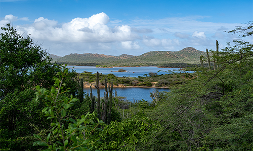
Bonaire, with Kralendijk as its capital, is the easternmost of the Leeward Islands. It lies between 68°11' and 68°25' W.L. and between 12°2'and 12°19'N.Br. The island is shaped somewhat like a hook. The concave side faces west. Its area is 288 km², its width varies between 5 and 12 km. The length is about 40 km, measured from Malmok in the north to Lacre Point in the south. There are rather large contrasts in the shape and structure of Bonaire. The northwest is hilly, the middle has terrace landscapes, and the south is low and flat.
In the northwest you will find the highest hills, the Brandaris is the highest at 240.8 m. The hilly landscape changes quite suddenly at Rincon into a lowland. It is bordered in the south by the approximately 100 m high steep edge of the limestone terrace landscape of central Bonaire. To the north and east, the terraces decrease in height in a stepped fashion.
This part of Bonaire is recognized by its many steep rock faces and numerous niches and caves. The high terrace of central Bonaire ends in the steep edge of Kibrá di Montaña (138 m). South of this, the island quickly becomes lower and flatter. It eventually turns into salt flats and wetlands at Punt Vierkant that are barely above sea level.
Bonaire has an elevated coral coastline that is higher and wilder on the north and east sides than on the south and west sides. On the north and east side, coves such as Boka Onima and Boka Washikemba appear in many places. Here and there, narrow sandy beaches were formed, playas, such as Playa Lechi on the west coast, among others. Bonaire also has valley systems that flooded in the Postglacial just like the Schottegat on Curaçao and serve perfectly as harbors.
But these have been completely or almost completely sealed off from the sea on Bonaire by subsequent coral formation and turned into saltwater lakes. Such as Boka Bartol, Slagbaai and Gotomeer, among others. In the south of Bonaire, the Brine Lake with an open connection to the sea has proved very important for salt production and as a breeding ground for flamingos.
A little further north on the east coast is Lac, an extensive lagoon partially closed by coral reefs. It is accessible to small boats. Fishermen have left large quantities of shells (karkos) at Lac. Much of the side of the lagoon is densely vegetated with mangrove plants. Many animals live and breed there. The south side of the lagoon is formed by a fairly wide sandy beach.
On the west side of Bonaire, about 2 km from the coast at Kralendijk, lies the uninhabited, low coral island Klein Bonaire with an area of about 6 km². Today it is covered with sparse scrub, this used to be different.
Bonaire's original vegetation is determined by the prevailing semi-arid climate. The average rainfall from 1905 to 1980 was 503.7 mm. The original plants are mainly shrubs with thorns, low trees and cacti. Mangrove plants grow near inland bays and low-growing plants that like salt water grow near the coast. he sabanas, meadows, used to be very important. They occur in a particular season. When the freshwater became salty, the sabanas almost disappeared completely.
There are natural freshwater springs at Dos Pos, Pos di Rincon, Fontein and also in the low limestone area of the south. In various places, people tried to get more water by drilling wells and building earthen dams in suitable places in grub. This is how ‘tankis’ and dams were formed. The northern half has significantly more forests than the southern half. Here are located most of the large plantations such as Washington, Slagbaai, Fountain, Bolivia, Colombia.
These forests are only a meager remnant of the dense forests with many more trees. From 1499 when the Spaniards visited the island until the beginning of the 20th century, the coveted Brazilwood (paint wood) and Wayaká (pock wood) were cut down. The many charcoal burnings for export to Curaçao and the extensive goat farming also caused much damage to the growth of trees.
Bonaire has been internationally known for its nature conservation for many years. And the designation, establishment and management of protected areas that fall under the Washington Slagbaai National Park and Bonaire Marine Park. In 1969, the non-profit organization Stichting Nationale Parken Bonaire (Stinapa) started the Washington Park. In 1979, the park was expanded with the purchase of Slagbaai. The Marine Park was established in 1979. The goal of both parks is to protect and preserve nature for posterity.
On the 21st November 2001 the Island Council finalized a development plan for Klein Bonaire. The Island is designated as a protected area and becomes part of Bonaire National Marine Park managed by STINAPA Bonaire, as described in the Environmental Marine Ordinance (2001).
Link to STINAPA (English):
https://stinapabonaire.org/bonaire-national-marine-park/klein-bonaire/
Video of Klein Bonaire (mostly in Papiamentu):

